Distance: Km 22
Estimated time: 5 h
Departure: Solarolo
Arrival: S. Maria in Quartolo
Description of the stage
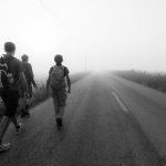
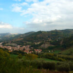
It starts from the center of the village where the church of S. Maria Assunta rises in an easterly direction passing Piazza del Popolo, cross the junction and proceed along the cycle path via G.Pascoli (22) passing the level crossing (via Felisio); continue along the provincial road until the junction and the bridge over the Senio river. We cross the right bank (the hydrographic left) passing a bar. We always run along the embankment to the highway, we go down to the left through a reed A14. We continue along the embankment that we will abandon following a carriage that runs along a series of well kept gardens and a horse farm. We stay on the carraia up to the graft with via Gradasso, turning left we pass the railway underpass. On asphalt we head towards the state road SS9 via Emilia, which we cross. We turn to the left and after having passed the river Senio to the right we take via Casale (sp 84) that we cross until the intersection with via Celle. We turn to the right remaining always on via Casale following indications for Villa Vezzano. After the Tre Re farm, turn left into Via Casale. Shortly after we reach the junction with Via Pergola: on our right votive pillar dated 1961 placed by the Masci. Keeping to the right for up and down we pass via Monti Coralli, meeting a memorial memorial placed in memory of a German reprisal occurred in October 1944 following the killing of a soldier by the Partisans. After a hundred meters turn left to climb uphill in the presence of an electric cabin towards the church S. Giovanni Battista and Andrea di Pergola that we reach after passing the local cemetery. Holding the left a bit ‘infrascato a short path leads us to the restaurant Pergola. Continuing to climb via Pergola, we leave Via Mercanta on the left. After short we cross via Rio Biscia that we leave to our left and we continue straight on via Pergola. For ups and downs the street changes its name to via Pideura; to our left remains the old cemetery now abandoned and superatolo curviamo left uphill towards the church S. Maria in Afri di Pideura. Turn left and soon reach a nice viewpoint with a view of the calanques and the Vena del Gesso. We are on trail 505 CAI. We take to the left via Berta we pass the street number 40 and we continue in descent and at the civic 52 turn right to carraia we skirt vineyards in steep descent, we sight a little lake to our left and one at the end of the runway. Here on the left we pass a bar that leads us into the valley of the S.Cristoforo river. After the carriageway, along the small river we pass an old building and we have a nice view on the ravines on our left. Continuing on the asphalt until the intersection with via Pideura we keep the left, we pass the railway and in front we find our destination: S. Maria in Quartolo.
Places of interest:
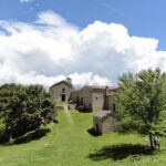
Church Saints John the Baptist and Andrea in Pergola: the first news of this church dates back to 1291. However, from news about the year 1137 we know the existence in this area of a castle and probably also of a residential settlement and of a place of worship dedicated to it due to the church of Pergola. No trace remains of the original building and the current church dates back to 1899, the paintings and furnishings that housed are kept in the Municipal Art Gallery and in the Diocesan Museum of Faenza.
Church of S. Maria in Afri in Pideura: on the site currently occupied by the modern church, rebuilt after the destruction of the Second World War, stood the ancient parish church of S. Maria in Apri or Afri or Auri. In the Middle Ages the word pieve from the Latin “plebs” (people of God) indicated a church with a baptismal font that exercised its jurisdiction over a certain territory where other minor churches existed. The first documents attest to the existence of the church since 883.
Church of S. Maria in Quartolo: the toponym refers to the fourth mile of the Roman road that went up the valley of the Lamone and corresponded to the distance from the Via Emilia. The first news about the place we find around 972 when there was probably a “curtis” called “quartuli”.